"Satellite Photo of Earth at Night"
Shown below is a famous NASA image that is often called a "satellite photo
of earth at night". It isn't really a "photo". Instead it is
an image that was compiled using data from the Defense Meteorological Satellite
Program. It is a map of the location of permanent lights on Earth's surface.
Each white dot on the map represents the light of a city. The entire
image is show below and we follow it with enlarged continents and commentary.
The luminosities shown on the map represent a geography of economic activity.
|
Satellite Photo of the World at Night
|
|
|
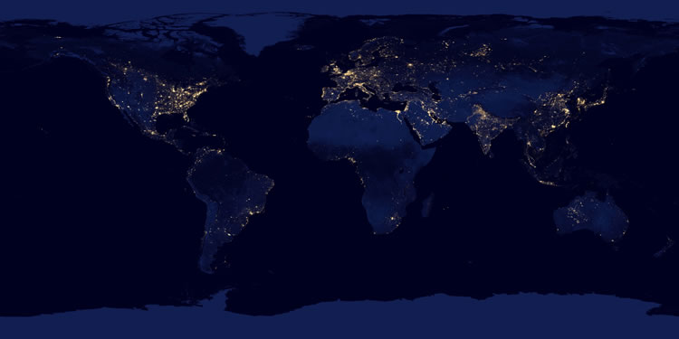 |
| This map shows the geographic distribution of cities. It clearly shows that cities are concentrated in Europe, the eastern United States, Japan, China and India.
It is a better map for showing the geography of night time electricity
consumption for outdoor lighting than it is for showing the geography
of population. For example: the
eastern United States is very bright but the more densely populated
areas of China and India are not nearly as bright in this image. NASA
Image. |
|
Satellite Photo of the United States at Night
|
|
 |
| This map shows the geographic distribution of night time lights in the United States, Canada, Mexico and the Caribbean. Strong lights occur in a strand that includes Washington, DC, Philadelphia, New Jersey, New York City and Boston. Most of the large cities of Canada are located within a couple hundred miles of the United States border. Chicago
stands out on the shoreline of Lake Michigan and other major cities in
the central states are collected by a network of highways. On the west
coast, Seattle, San Francisco, Los Angeles and San Diego stand out. The coastlines of Florida and Puerto Rico are lined with bright cities. Finally, the cities of Hawaii and oil facilities of the north Alaska coast are also "visible from space". NASA Image. |
|
Satellite Photo of Europe and Africa at Night
|
|
 |
| Western Europe is aglow with night lights. This image clearly
shows that the cities of Europe are along the coasts. The Mediterranean
coasts of Italy, France and Spain are a solid line of light as is the southern shorelines of the Black and Caspian Seas. The Sahara of northern Africa
and the jungles of south-central Africa are largely void of illuminated
cities. One of the most striking features on this image is the high
concentration of cities on the Nile River, downstream from the Aswan
Dam. NASA Image. |
|
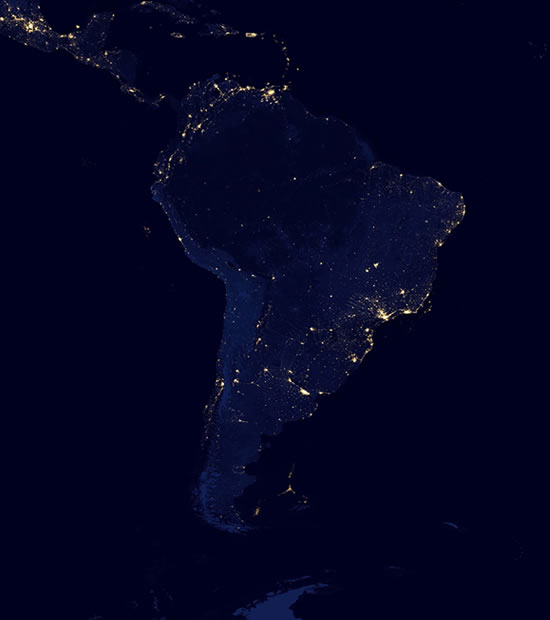
Satellite Photo of South America at Night
|
|
|
|
| The cities of South America are mainly concentrated on the southwestward-facing Atlantic coast, along the Pacific coast and northern Colombia and Venezuela.
Large areas of the Amazon Basin are without bright cities and some of
the night lights there might actually be the fires if deforestation and
agricultural burning. NASA Image. |
|
Satellite Photo of Asia and Australia at Night
|
|
 |
|
|
Source: http://geology.com/articles/satellite-photo-earth-at-night.shtml
|
|
Tidak ada komentar:
Posting Komentar
Bagaimana komentar Anda?