Recent Hawaii Volcano Photos
Kilauea Eruption
Photos of lava flows and more by the USGS Hawaiian Volcano Observatory.
Photos from early 2008 and late 2007.

A lava flow dumps into the Pacific Ocean, building the Waikupanaha lava delta. Multiple locations where lava streams into the ocean can be seen in this image along with a red-hot lava flow traversing the lava field. This photo shows the enormous extent of the flows. They extend from the shoreline up to the horizon. A volcanic plume from the Pu`u `O`o vent can be seen over the horizon.

A lava flow dumps into the Pacific producing enormous amounts of steam and a basalt pier.

View of the Halema`uma`u vent emitting ash-free steam. Taken from the Jaggar Museum overlook.

View of an ash-rich plume from Halema`uma`u from the southeast side of Kilauea Caldera. Note the ash fallout down-wind of the plume.

View of the Halema`uma`u Overlook parking area. The paved surface of the parking area was completely buried by a thin layer of pyroclastic debris.
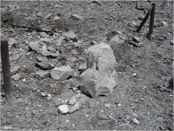
The largest blocks blasted out of Halema`uma`u were almost a meter across. This one landed on a steel cable fence adjacent to the Halema`uma`u Overlook trail.

From the air it can be difficult to spot where hot lava is flowing. The thermal image on the right is a heat map of the boxed area on the photo. It clearly shows a channelized flow and areas of hot `a`a.

A skylight in the main lava tube reveals the lava stream feeding the ocean entries in the distance.

A look into the skylight shown above, with lava stalactites forming on the roof of the tube.

A field of hot pahoehoe moving to the ocean. A thin skin on the flow forms the classic "rope" surface.

A channel of `a`a two yards wide flows through what used to be the Royal Gardens Subdivision.

The Waikupanaha and Ki entries, where lava flows into the ocean producing steam and a lava delta.

Map showing the Royal Gardens Subdivision, ocean lava entries and other features shown in the photos above. The most recent lava flow is shown in red. Click the map above to enlarge.
The photos above were taken by staff of the United States Geological Survey and the Hawaiian Volcano Observatory. Caption information was adapted from articles on the HVO website.
Sumber: http://geology.com/usgs/hawaii-volcano-pictures.shtml
Hey I know this is off topic but I was wondering if you knew of any widgets I could add to my blog that automatically tweet my newest twitter
BalasHapusupdates. I've been looking for a plug-in like this for quite some time and was hoping maybe you would have some experience with something like this. Please let me know if you run into anything. I truly enjoy reading your blog and I look forward to your new updates.
my blog :: cellulite treatment reviews